
Editor's Note: This story was originally published in the October 2001 issue of Scientific American.
The boxes are stacked eight feet high and line the walls of the large, windowless room. Inside them are new body bags, 10,000 in all. If a big, slow-moving hurricane crossed the Gulf of Mexico on the right track, it would drive a sea surge that would drown New Orleans under 20 feet of water. "As the water recedes," says Walter Maestri, a local emergency management director, "we expect to find a lot of dead bodies."
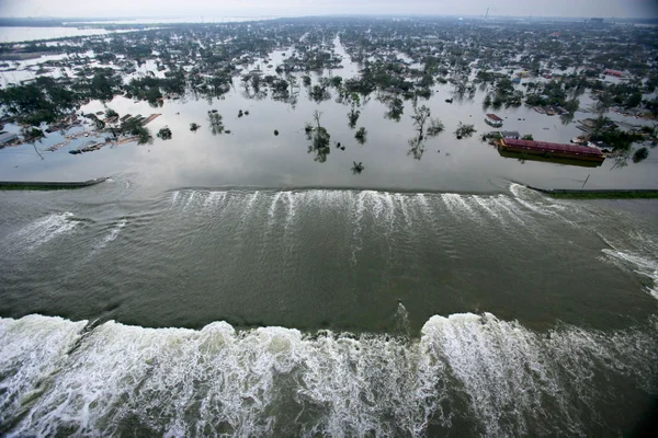
New Orleans is a disaster waiting to happen. The city lies below sea level, in a bowl bordered by levees that fend off Lake Pontchartrain to the north and the Mississippi River to the south and west. And because of a damning confluence of factors, the city is sinking further, putting it at increasing flood risk after even minor storms. The low-lying Mississippi Delta, which buffers the city from the gulf, is also rapidly disappearing. A year from now another 25 to 30 square miles of delta marsh--an area the size of Manhattan--will have vanished. An acre disappears every 24 minutes. Each loss gives a storm surge a clearer path to wash over the delta and pour into the bowl, trapping one million people inside and another million in surrounding communities. Extensive evacuation would be impossible because the surging water would cut off the few escape routes. Scientists at Louisiana State University (L.S.U.), who have modeled hundreds of possible storm tracks on advanced computers, predict that more than 100,000 people could die. The body bags wouldn't go very far.
On supporting science journalism
If you're enjoying this article, consider supporting our award-winning journalism by subscribing. By purchasing a subscription you are helping to ensure the future of impactful stories about the discoveries and ideas shaping our world today.
A direct hit is inevitable. Large hurricanes come close every year. In 1965 Hurricane Betsy put parts of the city under eight feet of water. In 1992 monstrous Hurricane Andrew missed the city by only 100 miles. In 1998 Hurricane Georges veered east at the last moment but still caused billions of dollars of damage. At fault are natural processes that have been artificially accelerated by human tinkering--levying rivers, draining wetlands, dredging channels and cutting canals through marshes. Ironically, scientists and engineers say the only hope is more manipulation, although they don't necessarily agree on which proposed projects to pursue. Without intervention, experts at L.S.U. warn, the protective delta will be gone by 2090. The sunken city would sit directly on the sea--at best a troubled Venice, at worst a modern-day Atlantis.
As if the risk to human lives weren't enough, the potential drowning of New Orleans has serious economic and environmental consequences as well. Louisiana's coast produces one third of the country's seafood, one fifth of its oil and one quarter of its natural gas. It harbors 40 percent of the nation's coastal wetlands and provides wintering grounds for 70 percent of its migratory waterfowl. Facilities on the Mississippi River from New Orleans to Baton Rouge constitute the nation's largest port. And the delta fuels a unique element of America's psyche; it is the wellspring of jazz and blues, the source of everything Cajun and Creole, and the home of Mardi Gras. Thus far, however, Washington has turned down appeals for substantial aid.
Fixing the delta would serve as a valuable test case for the country and the world. Coastal marshes are disappearing along the eastern seaboard, the other Gulf Coast states, San Francisco Bay and the Columbia River estuary for many of the same reasons besetting Louisiana. Parts of Houston are sinking faster than New Orleans. Major deltas around the globe--from the Orinoco in Venezuela, to the Nile in Egypt, to the Mekong in Vietnam--are in the same delicate state today that the Mississippi Delta was in 100 to 200 years ago. Lessons from New Orleans could help establish guidelines for safer development in these areas, and the state could export restoration technology worldwide. In Europe, the Rhine, Rh¿ne and Po deltas are losing land. And if sea level rises substantially because of global warming in the next 100 years or so, numerous low-lying coastal cities such as New York would need to take protective measures similar to those proposed for Louisiana.�
Seeing Is Believing
Shea Penland is among those best suited to explain the delta's blues. Now a geologist at the University of New Orleans, he spent 16 years at L.S.U.; does contract work for the U.S. Army Corps of Engineers, which builds the levees; sits on federal and state working groups implementing coastal restoration projects; and consults for the oil and gas industry. His greatest credential, however, is that he knows the local folk in every little bayou town, clump of swamp and spit of marsh up and down the disintegrating coast--the people who experience its degradation every day.
Penland, dressed in jeans and a polo shirt on a mid-May morning, is eager to get me into his worn red Ford F150 pickup truck so we can explore what's eating the 50 miles of wet landscape south of New Orleans. The Mississippi River built the delta plain that forms southeastern Louisiana over centuries by depositing vast quantities of sediment every year during spring floods. Although the drying sands and silts would compress under their own weight and sink some, the next flood would rebuild them. Since 1879, however, the Corps of Engineers, at Congress's behest, has progressively lined the river with levees to prevent floods from damaging towns and industry. The river is now shackled from northern Louisiana to the gulf, cutting off the sediment supply. As a result, the plain just subsides below the encroaching ocean. As the wetlands vanish, so does New Orleans's protection from the sea. A hurricane's storm surge can reach heights of more than 20 feet, but every four miles of marsh can absorb enough water to knock it down by one foot.
The flat marsh right outside New Orleans is still a vibrant sponge, an ever changing mix of shallow freshwater, green marsh grasses and cypress swamp hung with Spanish moss. But as Penland and I reach the halfway point en route to the gulf, the sponge becomes seriously torn and waterlogged. Isolated roads on raised stone beds pass rusted trailer homes and former brothels along now flooded bayous; stands of naked, dead trees; and browned grasses and reaches of empty water.
Down in Port Fourchon, where the tattered marsh finally gives way to open gulf, the subsidence and erosion are aggressive. The lone road exists only to service a collection of desolate corrugated buildings where oil and natural-gas pipelines converge from hundreds of offshore wellheads. Countless platforms form a gloomy steel forest rising from the sea. To bring in the goods, the fossil fuel companies have dredged hundreds of miles of navigation channels and pipeline canals throughout the coastal and interior marshes. Each cut removes land, and boat traffic and tides steadily erode the banks. The average U.S. beach erodes about two feet a year, Penland says, but Port Fourchon loses 40 to 50 feet a year--the fastest rate in the country. The network of canals also gives saltwater easy access to interior marshes, raising their salinity and killing the grasses and bottomwood forests from the roots up. No vegetation is left to prevent wind and water from wearing the marshes away. In a study funded by the oil and gas industry, Penland documented that the industry has caused one third of the delta's land loss.
Alligator Science
The Duet brothers know firsthand how various factors accelerate land loss beyond natural subsidence. Toby and Danny, two of Penland's local pals along our route, live on a 50-foot beige barge complex anchored in the middle of 15 square miles of broken marsh, some 20 miles northwest of Port Fourchon. Their family leased the land from oil companies, for fishing and hunting, 16 years ago when it was merely wet. Now it lies under five to eight feet of water. They filter rain for drinking water, process their own sewage, catch the food they eat and make money hosting overnight fishing parties for sportsmen. A dozen wellheads dot the marsh where Toby picks us up by boat. Heading out to the barge through one canal, he says, "I used to be able to spit to the mud on either side. Now they run big oil containers through here."�
Inside the barge's wide-open room, Danny offers other measures: "Two years ago we drove a wooden two-by-four into the mud on the edge of a canal, to stake our alligator trap. I went past it the other day; the edge has receded 18 feet from the stake. Doesn't much matter, though. The gators are gone. Water's too salty."
With the marsh disappearing, the delta's only remaining defense is some crumbling barrier islands that a century ago were part of the region's shoreline. The next morning Penland and I travel an hour down the coast to the Louisiana Universities Marine Consortium, a scientific outpost in Cocodrie, an encampment of scientists and fishermen on the coast's edge. From there we head out in one of the consortium's gray research boats.
The boat pounds across what appears to be choppy sea for 50 minutes before we reach Isles Dernieres ("last islands" in French). But the open surf is never more than seven feet deep. The vast reach of shallow water was once thick with swaying grasses, parted occasionally by narrow, serpentine waterways full of shrimp, oysters, redfish and trout. Penland beaches us in the bayside mud. We walk across a mere 80 yards of barren sand before we toe the ocean. A similarly diminutive outcrop is visible in the distance to either side. They are what remains of a once very long, staunch island lush with black mangroves. "It broke up ocean waves, cut down storm surges and held back saltwater so the marsh behind it could thrive," Penland says in mourning. Now the ocean rushes right by.
Louisiana's barrier islands are eroding faster than any around the country. Millions of tons of sediment used to exit the Mississippi River's mouth every year and be dragged by longshore currents to the islands, building up what tides had worn away. But in part because levees and dredging prevent the river's last miles from meandering naturally, the mouth has telescoped out to the continental shelf. The sediment just drops over the edge of the underwater cliff into the deep ocean.
Back in New Orleans the next day it becomes apparent that other human activities have made matters worse. Cliff Mugnier, an L.S.U. geodesist who also works part-time for the Corps of Engineers, explains why from the third floor of the rectangular, cement Corps headquarters, which squats atop the Mississippi River levee the Corps has built and rebuilt for 122 years.
Mugnier says that the earth beneath the delta consists of layers of muck--a wet peat several hundred feet deep--formed by centuries of flooding. As the Corps leveed the river, the city and industry drained large marshes, which in decades past were considered wasteland. Stopping the floods and draining surface water lowered the water table, allowing the top mucks to dry, consolidate and subside, hastening the city's drop below sea level--a process already under way as the underlying mucks consolidated naturally.
That's not all. As the bowl became deeper, it would flood during routine rainstorms. So the Corps, in cooperation with the city's Sewerage and Water Board, began digging a maze of canals to collect rainwater. The only place to send it was Lake Pontchartrain. But because the lake's mean elevation is one foot, the partners had to build pumping stations at the canal heads to push the collected runoff uphill into the lake.
The pumps serve another critical function. Because the canals are basically ditches, groundwater seeps into them from the wet soils. But if they are full, they can't take on water during a storm. So the city runs the pumps regularly to expel seepage from the canals, which draws even more water from the ground, leading to further drying and subsidence. "We are aggravating our own problem," Mugnier says. Indeed, the Corps is building more canals and enlarging pumping stations, because the lower the city sinks, the more it floods. In the meantime, streets, driveways and backyards cave in, and houses blow up when natural-gas lines rupture. Mugnier is also worried about the parishes (counties) bordering the city, which are digging drainage canals as they become more populated. In St. Charles Parish to the west, he says, "the surface could subside by as much as 14 feet."�
The Scare
Humankind can't stop the delta's subsidence, and it can't knock down the levees to allow natural river flooding and meandering, because the region is developed. The only realistic solutions, most scientists and engineers agree, are to rebuild the vast marshes so they can absorb high waters and reconnect the barrier islands to cut down surges and protect the renewed marshes from the sea.
Since the late 1980s Louisiana's senators have made various pleas to Congress to fund massive remedial work. But they were not backed by a unified voice. L.S.U. had its surge models, and the Corps had others. Despite agreement on general solutions, competition abounded as to whose specific projects would be most effective. The Corps sometimes painted academics' cries about disaster as veiled pitches for research money. Academia occasionally retorted that the Corps's solution to everything was to bulldoze more dirt and pour more concrete, without scientific rationale. Meanwhile oystermen and shrimpers complained that the proposals from both the scientists and the engineers would ruin their fishing grounds.
Len Bahr, head of the governor's Coastal Activities Office in Baton Rouge, tried to bring everyone together. Passionate about southern Louisiana, Bahr has survived three governors, each with different sympathies. "This is the realm in which science has to operate," Bahr says. "There are five federal agencies and six state agencies with jurisdiction over what happens in the wetlands." Throughout the 1990s, Bahr says with frustration, "we only received $40 million a year" from Congress, a drop compared with the bucket of need. Even with the small projects made possible by these dollars, Louisiana scientists predicted that by 2050 coastal Louisiana would lose another 1,000 square miles of marsh and swamp, an area the size of Rhode Island.
Then Hurricane Georges arrived in September 1998. Its fiercely circulating winds built a wall of water 17 feet high topped with driven waves, which threatened to surge into Lake Pontchartrain and wash into New Orleans. This was the very beast that L.S.U.'s early models had warned about, and it was headed right for the city. Luckily, just before Georges made landfall, it slowed and turned a scant two degrees to the east. The surge collapsed under suddenly chaotic winds.
A Grand Plan
The scientists, engineers and politicians who had been squabbling realized how close the entire delta had come to disaster, and Bahr says that it scared them into reaching a consensus. Late in 1998 the governor's office, the state's Department of Natural Resources, the U.S. Army Corps of Engineers, the Environmental Protection Agency, the Fish and Wildlife Service and all 20 of the state's coastal parishes published Coast 2050--a blueprint for restoring coastal Louisiana.
No group is bound by the plan, however, and if all the projects were pursued, the price tag would be $14 billion. "So," I ask in the ninth-floor conference room adjacent to the governor's office in Baton Rouge, "give me the short list" of Coast 2050 projects that would make the most difference. Before me are Joe Suhayda, director of L.S.U.'s Louisiana Water Resources Research Institute, who has modeled numerous storm tracks and knows the key scientists, Corps engineers, and city emergency planners; Vibhas Aravamuthan, who programs L.S.U.'s computer models; Len Bahr; and Bahr's second-in-command, Paul Kemp. All were involved in designing Coast 2050.
First and foremost, they decide, build a river diversion at several critical spots along the Mississippi, to restore disappearing marshland. At each location the Corps would cut a channel through the river levee on its south side and build control gates that would allow freshwater and suspended sediment to wash down through select marshes toward the gulf. The water could disrupt oyster beds, but if the sites were carefully selected, deals could be made with landowners.�
Every 24 minutes Louisiana loses one acre of land.
The second step: rebuild the southern barrier islands using more than 500 million cubic yards of sand from nearby Ship Shoal. Next, the Corps would cut a channel in the narrow neck of the river delta at about halfway down. Ships could enter the river there, shortening their trip to interior ports and saving them money. The Corps could then stop dredging the southern end of the river. The mouth would fill with sediment and begin overflowing to the west, sending sand and silt back into those longshore currents that could sustain the barrier islands.
The channel plan might be integrated into a larger state proposal to build an entire new Millennium Port. It would provide deeper draft for modern container ships than the Port of New Orleans and its main channel, the Mississippi River Gulf Outlet (MRGO, pronounced Mr. Go), which the Corps dredged in the early 1960s. The outlet has eroded terribly--from 500 feet across, originally, to 2,000 feet in places--and let in a relentless stream of saltwater that has killed much of the marsh that once protected eastern New Orleans against gulf storms. If the channel or the Millennium Port were built, the Corps could close MrGo.
A remaining chink in the delta's armor is the pair of narrow straits on Lake Pontchartrain's eastern edge where it connects to the gulf. The obvious solution would be to gate them, just as the Netherlands does to regulate the North Sea's flow inland. But it would be a tough sell. "We've proposed that in the past, and it's been shot down," Bahr says. The project's costs would be extremely high.
This list of the most promising Coast 2050 projects is only one small group's vision, of course, yet other established experts concur with its fundamentals. Ivor van Heerden, a geologist who is deputy director of L.S.U.'s Hurricane Center, concurs that "if we're going to succeed, we've got to mimic nature. Building diversions and reestablishing barrier-island sediment flows are the closest we can come." Shea Penland pretty much agrees, although he warns that the Mississippi River may not carry enough sediment to feed multiple diversions. U.S. Geological Survey studies by Robert Meade show that the supply of suspended sediment is less than half of what it was prior to 1953, diverted mostly by dams along the river's course through middle America.
With no action, one million people could be trapped.
As far as the Corps is concerned, all of the Coast 2050 projects should be implemented. The first to become a reality is the Davis Pond diversion, due to begin operating by the end of this year. Project manager Al Naomi, a 30-year Corps civil engineer, and Bruce Baird, a biological oceanographer, brought me to the construction site on the Mississippi's southern levee, 20 miles west of New Orleans. The structure looks like a modest dam, in line with the levee. Steel gates in its midsection, each large enough to drive a bus through, will open and close to control water flowing through it. The water will exit into a wide swath of cleared swamp that extends south for a mile, forming a shallow riverbed that will gradually disperse into boundary-less marsh. The structure will divert up to 10,650 cubic feet per second (cfs) of water from the Mississippi, whose total flow past New Orleans ranges from less than 200,000 cfs during droughts to more than one million cfs during floods. The outflow should help preserve 33,000 acres of wetlands, oysterbeds and fishing grounds.
The Corps is bullish on Davis Pond because of its success at Caernarvon, a smaller, experimental diversion it opened in 1991 near MrGo. By 1995 Caernarvon had restored 406 acres by increasing the marsh's sediment and reducing its salinity with freshwater.
Who Should Pay?
The corps of engineers is hiring more scientists for projects such as Davis Pond, a signal that the fragmented parties are beginning to work better together. Bahr would like to integrate science and engineering further by requiring independent scientific review of proposed Corps projects before the state signed on--which Louisiana would need to do because Congress would require the state to share the cost of such work.�
If Congress and President George W. Bush hear a unified call for action, authorizing it would seem prudent. Restoring coastal Louisiana would protect the country's seafood and shipping industries and its oil and natural-gas supply. It would also save America's largest wetlands, a bold environmental stroke. And without action, the million people outside New Orleans would have to relocate. The other million inside the bowl would live at the bottom of a sinking crater, surrounded by ever higher walls, trapped in a terminally ill city dependent on nonstop pumping to keep it alive.
Funding the needed science and engineering would also unearth better ways to save the country's vanishing wetlands and the world's collapsing deltas. It would improve humankind's understanding of nature's long-term processes--and the stakes of interfering, even with good intentions. And it could help governments learn how to minimize damage from rising seas, as well as from violent weather, at a time when the U.S. National Oceanic and Atmospheric Administration predicts more storms of greater intensity as a result of climate change.
Walter Maestri doesn't welcome that prospect. When Allison, the first tropical storm of the 2001 hurricane season, dumped five inches of rain a day on New Orleans for a week in June, it nearly maxed out the pumping system. Maestri spent his nights in a flood-proof command bunker built underground to evade storm winds; from there he dispatched police, EMTs, firefighters and National Guardsmen. It was only rain, yet it stressed the response teams. "Any significant water that comes into this city is a dangerous threat," he says. "Even though I have to plan for it, I don't even want to think about the loss of life a huge hurricane would cause."�
