
A massive winter storm that is expected to bring snow and ice to the eastern United States in the next 24 hours dwarfs the central part of the country in a new satellite image.
The National Oceanic and Atmospheric Administration's GOES-West satellite spotted this cloudy view of the large storm near the Gulf Coast yesterday (Jan. 21) at 10 a.m. EST. (The satellite photo also spied a separate storm swirling over the Pacific Ocean.)
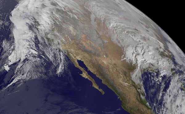
The NASA-NOAA Suomi NPP satellite captured another view of the looming winter storm Wednesday (Jan. 20) at 2:30 p.m. EST, showing clouds and snow cover stretching from northern Texas into the Great Lakes states. The low-pressure system, which originated in the Eastern Pacific, is headed toward the mid-Atlantic states. The National Weather Service is warning of a potentially "crippling" snowstorm in those areas today and Saturday. [VIDEO: Watch the Developing Storm from Space]
On supporting science journalism
If you're enjoying this article, consider supporting our award-winning journalism by subscribing. By purchasing a subscription you are helping to ensure the future of impactful stories about the discoveries and ideas shaping our world today.
Much of the East, from as far south as northern Georgia to as far north as New York City, is under weather alert, ranging from winter storm warnings in eastern Tennessee, Kentucky and western North Carolina to a blizzard watch in Washington, D.C, Baltimore and up the I-95 corridor through New Jersey.
"At this moment, this still looks like it's going to be northern Virginia and Maryland's most memorable snow," said David Robinson, the state climatologist of New Jersey. "A question remains just where exactly the heaviest snowfall totals will fall, just where the strongest winds will be and where the coastal flooding will be worst."
Volatile winter
The storm will track across the Tennessee Valley on Friday, ultimately hitting the mid-Atlantic states Saturday, with lessening snow expected by Sunday. Storms like the one bearing down on the eastern United States typically have a band of heavy snowfall about 100 miles (161 kilometers) wide, Robinson told Live Science. North of this band, precipitation peters out, leading to low overall totals. South of this band, temperatures are warm enough that snow turns to rain.
"This is a multifaceted nor'easter, as they all tend to be, laden with strong wind and impacts on the coast and heavy precipitation of one form or another," Robinson said.
El Niño's influence may also be at play, Robinson said. The storm "fits the pattern of volatility that we often see in weather, really across the country, during an El Niño winter," he said.
The winter of 2015-2016 has so far been marked by an active storm pattern in the western United States, with unseasonably warm temperatures and unusual midwinter thunderstorms in the South. In late December and early January, the Mississippi River flooded to levels not seen since 1993, thanks to heavy snows and rainfall in the western and central parts of the country. A rare December tornado outbreak from Indiana to Alabama killed 13 people between Dec. 23 and Dec. 25.
Meanwhile, warm temperatures made Christmas a balmy holiday for many on the East Coast. New York City experienced its warmest Christmas on record, with temperatures reaching 66 degrees Fahrenheit (19 degrees Celsius). On Christmas Eve, the mercury hit 72 degrees F (22 degrees C) at LaGuardia Airport in New York, breaking a 76-year record. The previous high temperature that day, according to NOAA's National Centers for Environmental Information, was 63 degrees F (17 degrees C).
Ice, wind and floods
If volatility is a feature of El Niño winters in the United States, so is an active East Coast storm track, Robinson said.
"We have seen coastal storms aplenty during El Niño winters," he said. Those storms don't always translate to snow, though, he added. Some mid-Atlantic El Niño years have been virtually snow-free, while others have seen large snowstorms.
Regardless of snow totals, the incoming storm is likely to be a major event, meteorologists say. Forecasts predict water levels 3 to 4 feet higher than normal along the New Jersey coast down into Delaware, Robinson said, and winds could gust more than 60 mph (96.5 km/h).
Washington, D.C., and the surrounding area is under a blizzard warning, with about 24 inches (60 centimeters) of snow expected for the capital city and 24 to 30 inches (60 to 76 cm) in the western suburbs, according to the National Weather Service. Gusty winds, ice and up to a foot (30 cm) of snow are expected in Kentucky. Detailed regional weather advisories and forecaster discussions can be found at http://www.weather.gov/.
Copyright 2015 LiveScience, a Purch company. All rights reserved. This material may not be published, broadcast, rewritten or redistributed.
