December 28, 2010
1 min read
 Add Us On GoogleAdd SciAm
After the Storm: Satellite catches U.S. East Coast blizzard moving out to sea
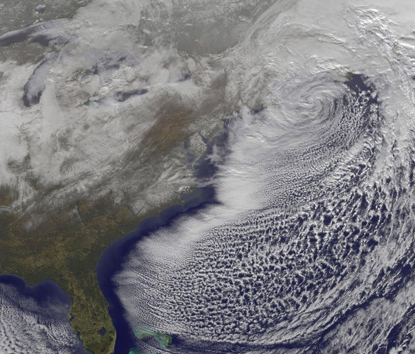
The U.S. East Coast endured a powerful blizzard over the past several days that dumped more than a meter of snow in some locations.
On supporting science journalism
If you're enjoying this article, consider supporting our award-winning journalism by subscribing. By purchasing a subscription you are helping to ensure the future of impactful stories about the discoveries and ideas shaping our world today.
The U.S. East Coast endured a powerful blizzard over the past several days that dumped more than a meter of snow in some locations. NASA's Geostationary Operational Environment Satellite (GOES-13) caught this picture of the storm moving out to sea late Monday night, leaving behind a whitened landscape from at least North Carolina to New York.
The storm also boasted powerful winds gusting up to 80 kilometers per hour, qualifying the nor'easter as a "strong gale" per the hurricane-measuring Beaufort scale. In fact, residual winds meant continued winter weather warnings for much of the East Coast through Tuesday.
It’s Time to Stand Up for Science
If you enjoyed this article, I’d like to ask for your support. Scientific American has served as an advocate for science and industry for 180 years, and right now may be the most critical moment in that two-century history.
I’ve been a Scientific American subscriber since I was 12 years old, and it helped shape the way I look at the world. SciAm always educates and delights me, and inspires a sense of awe for our vast, beautiful universe. I hope it does that for you, too.
If you subscribe to Scientific American, you help ensure that our coverage is centered on meaningful research and discovery; that we have the resources to report on the decisions that threaten labs across the U.S.; and that we support both budding and working scientists at a time when the value of science itself too often goes unrecognized.
In return, you get essential news, captivating podcasts, brilliant infographics, can't-miss newsletters, must-watch videos, challenging games, and the science world's best writing and reporting. You can even gift someone a subscription.
There has never been a more important time for us to stand up and show why science matters. I hope you’ll support us in that mission.