
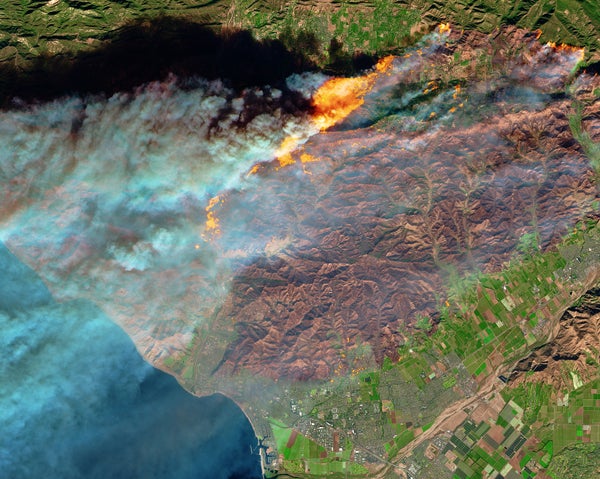
California's 2017 wildfire season is poised to shatter records as the 155,000-acre Thomas Fire in Ventura County continued to grow over the weekend, placing it among the state's 20 largest wildfires dating to the 1930s, according to a database maintained by the California Department of Forestry and Fire Protection (Cal Fire).
Two other large fires also continued to burn north of Los Angeles: the 15,600-acre Creek Fire consuming the western portion of the Angeles National Forest near San Fernando, and the more than 6,000-acre Rye Fire near Val Verde and the Interstate 5 corridor. Both of those fires were between 85 and 90 percent contained as of yesterday, according to data from Cal Fire.
To the south, in San Diego County, the 4,100-acre Lilac Fire near Palo Verde also continued to threaten homes and property over the weekend as it spread across the dry landscape riding westerly Santa Ana winds.
On supporting science journalism
If you're enjoying this article, consider supporting our award-winning journalism by subscribing. By purchasing a subscription you are helping to ensure the future of impactful stories about the discoveries and ideas shaping our world today.
Experts say the extent and destructive force of this winter's fires is not coincidental. The effects of climate change—including higher average temperatures, drier conditions and abundant fuels—are evident, they say.
On Saturday, after touring fire damage in Ventura County, California Gov. Jerry Brown (D) called the wildfires that have displaced more than 90,000 people "the new normal," adding that climate change may exacerbate conditions that lead to firestorms. "This could be something that happens every year or every few years," Brown said, according to reporting by the Los Angeles Times.
Research published in recent years also points to mounting evidence of such linkages.
A 2016 study authored by Climate Central in Princeton, N.J., found that the Western fire season is now 105 days longer than in 1970, and that the number of large fires and amount of acres burned has increased between 300 and 600 percent.
And according to data compiled by the nonprofit group Climate Nexus, 14 of California's 20 largest wildfires on record have occurred since 2000.
"Temperatures are rising in California, which just endured its worst heat wave on record in early September," the group said. "Rising temperatures are drying out the landscape, amplifying drought conditions, and lengthening the wildfire season in California."
Meanwhile, the property risk associated with California's current megafires is mounting. The real estate analytics firm CoreLogic on Friday published its first estimate of the number of California homes that could be lost to fire.
In Ventura and Los Angeles counties, where the Thomas, Creek and Rye fires pose the greatest threat, CoreLogic estimates that more than 86,200 homes face some level of risk, while more than 13,500 are in the "high" or "extreme" risk categories.
The reconstruction cost value (RCV) of the highest-risk homes is more than $5 billion, according to CoreLogic, while the RCV of all at-risk homes in Southern California exceeds $27.7 billion. Such estimates are based on a total loss scenario for the affected homes and could be lower depending on the amount of damage caused.
Reprinted from Climatewire with permission from E&E News. E&E provides daily coverage of essential energy and environmental news at www.eenews.net.