
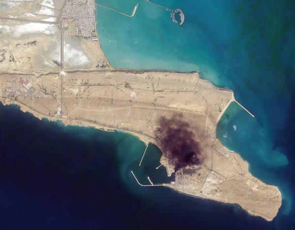
The day after the U.S. and Israel began the current war with Iran, satellite company Planet Labs e-mailed a media release. “Sharing our first batch of areas impacted by airstrikes,” it read. Planet operates a constellation of about 200 satellites that together can take pictures of much of Earth—including the parts in turmoil—daily. The release included a link to images taken that day of collapsed tunnels at a missile base and smoke over a naval facility.
As Planet’s message illustrates, governments, journalists and ordinary observers alike can now see what is happening across the globe soon after it happens, thanks to infrastructure in space. This relatively new ability is a result of the proliferation of “remote-sensing” satellites like Planet’s, which look down at Earth constantly.
Planet’s hundreds of remote-sensing spacecraft share the sky with hundreds more, and together they’re pushing society toward what has been called the GEOINT singularity: a time when geospatial intelligence will be available in real time to the average person, who will be able to see not just what the world looks like but how it is changing. The world hasn’t quite reached that tipping point. But merely approaching it has changed warfare for good.
On supporting science journalism
If you're enjoying this article, consider supporting our award-winning journalism by subscribing. By purchasing a subscription you are helping to ensure the future of impactful stories about the discoveries and ideas shaping our world today.
The U.S. government has operated spy satellites since the late 1950s, but it wasn’t until 1992 that private companies got the go-ahead to operate their own. Today commercial remote-sensing satellites are ubiquitous: Igor Morić of Princeton University, whose research includes ways for satellites to be used in arms control, calculates that with their combined powers as a “superconstellation,” they could image every spot on the planet every few hours.
Some of the sharpest eyes in the sky belong to a company called Vantor, whose satellites can resolve objects the size of a cutting board from orbit. Its 10 satellites can’t cover the globe in the same way Planet’s hundreds can, but they can return to high-priority spots 15 times a day and deliver pictures in as little as 15 minutes. Vantor has also used its data to make 2D and 3D maps of most of the world, updated the same day new intelligence arrives.
The U.S. and allied governments that Vantor does business with want what CEO Dan Smoot calls “their living globe”—“so they can see their world updated in real time and can see anything that’s changing within that world,” he says. But private satellites don’t just take pictures anymore: they can detect a variety of wavelengths and carry instruments such as radar and devices that can pick up radio transmissions, presenting a rapidly refreshed view of the planet beyond what the human eye can perceive.
Even as Earth approaches the GEOINT singularity, truth and transparency don’t always win out.
One company working with these nonvisual signals is HawkEye 360, which uses 30 satellites to detect and pinpoint radio transmissions. It can revisit most places every hour or so. “It’s one of those modalities that you can’t fully hide from,” says Todd Probert, HawkEye’s chief operating officer. That’s particularly useful for tracking ships, something people have been interested in doing in the Strait of Hormuz, where the conflict with Iran choked off oil shipping.
Ships that want to go invisible may turn off their automated identification systems or spoof their GPS location so—magic!—they appear to be somewhere they’re not. But they can’t hide all their radio transmissions, such as the ones radar systems beam out. HawkEye’s satellites can pick up those beams and triangulate a position—then, maybe with help from satellites that take pictures, confirm who’s out there.
HawkEye’s spacecraft can also sense GPS disruption, showing military officials where someone is jamming or spoofing a signal to make traditional geolocation and navigation unreliable.
With so many kinds of satellites, the prevailing logic goes, it has become much harder to conceal military activity aboveground. Going underground can obscure the action, but it’s hard to wage an entire war from a bunker.
As the Planet press release shows, near-real-time satellite data allow governments to tout their destructive successes; the information also makes denials harder. In tense but nominally peaceful times, satellites can prevent escalation by easing fears of an impending attack. Morić, for instance, advocates using satellite data to verify nuclear treaties (if those continue to exist) by counting missiles in images taken from above.
But, counterintuitively, too much transparency can be dangerous, Morić cautions. Nuclear deterrence, for example, rests on the idea that both sides know they could destroy each other. But if the U.S. has up-to-the-minute information about, say, the location of China’s mobile missile launchers, that visibility could undermine China’s ability to retaliate in kind. And that vulnerability undercuts the logic of mutually assured destruction and paradoxically might make the use of nukes more likely.
Satellites also let countries communicate without words. Knowing that satellites were watching, Russia recently unveiled a new bomber by leaving it outside long enough for U.S. satellites to get a good look, according to Morić. But a few things in life are certain: death, taxes and militaries’ desire to deceive their adversaries. So even as Earth approaches the GEOINT singularity, truth and transparency don’t always win out.
For one thing, real digital images can be modified with artificial intelligence, or fake ones can be conjured out of whole cloth. Deception can also go analog: Russia and Ukraine have used fake military equipment—inflatable and wood tanks, for example—to fool sensors. Russia has also painted exact silhouettes of its bombers onto runways.
The truth, in other words, isn’t so straightforward. And neither is access to it: private satellite companies are under no obligation to make their data available promptly; their decisions about when and how to do so, and to whom, make them geopolitical power players. Planet, for instance—the company that sent out the poststrike press releases early in the war with Iran—announced it would delay the release of images from some geographic areas in the Middle East for 14 days.
Planet doesn’t have a monopoly on satellite imagery, and neither does the U.S., so that delay doesn’t mean no one can see what’s happening. But the ability to selectively limit access to ground truth can have real consequences. For instance, the New York Times confirmed the U.S.’s errant strike on an Iranian elementary school by using satellite imagery. Without access to those images, the world might have lived with doubt or been left to weigh the conflicting accounts of governments with every reason to spin.
Turns out, when it comes to the satellite industry and the GEOINT singularity fulfilling their ultimate promise, technology isn’t the main barrier: it’s humans’ persistent desire to keep secrets and fool one another.
