
CLIMATEWIRE | Forecasters warned for days that Tampa could be staring down "the big one" — a direct hit from a major hurricane that threatened to submerge much of Florida's second-largest metro area with never-before-seen storm surge.
The nightmare scenario didn’t happen. Hurricane Milton tracked slightly south of its worst-case trajectory, making landfall Wednesday night in Sarasota County. Storm surge, overall, was lower than the water levels driven by Hurricane Helene two weeks prior.
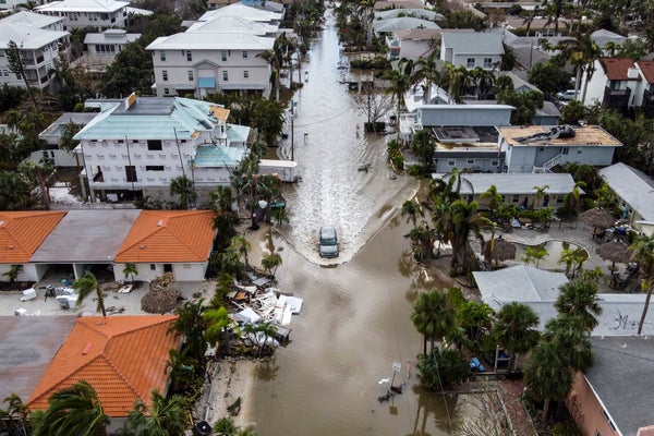
Yet it was still a record-breaking storm, dumping historic rainfall along the coast and spawning tornadoes that carved a path of destruction across multiple counties.
On supporting science journalism
If you're enjoying this article, consider supporting our award-winning journalism by subscribing. By purchasing a subscription you are helping to ensure the future of impactful stories about the discoveries and ideas shaping our world today.
Scientists say climate change, including unusually warm waters in the Gulf of Mexico, likely worsened its explosive intensification into a Category 5 cyclone before it weakened and made landfall as a Category 3.
“What we can say is the storm was significant, but thankfully this was not the worst-case scenario,” Florida Gov. Ron DeSantis said at a press briefing Thursday morning.
Tampa was spared largely thanks to a southward wobble in Milton’s track in the final hours before landfall, sending the storm toward Sarasota.
That doesn’t mean projections by the National Weather Service were inaccurate, said Austen Flannery, a meteorologist with the National Weather Service's Tampa office. Landfall still happened well within the forecast’s cone of uncertainty.
“Overall, the end result was relatively consistent with the forecast,” he said.
Preliminary estimates suggest storm surge was highest in Sarasota County, he said, likely around 8 to 10 feet. That’s significantly less than the 15 feet the National Weather Service had warned was possible for Tampa.
Yet widespread flooding still occurred across the state — partly from surge, but largely because of heavy rains.
Parts of Tampa were pelted with more than 10 inches of rainfall. Tampa International Airport recorded 11.73 inches, according to the National Weather Service. And the nearby city of St. Petersburg saw nearly 19 inches of rain, a monthly record.
“In two days, we had more rain than we’ve ever had in the month of October at that location,” Flannery said.
Strong winds also blasted the Tampa Bay region, downing trees and power lines, damaging homes and businesses, and ripping the roof off Tropicana Field, the stadium that’s home to the Tampa Bay Rays in St. Petersburg. Preliminary datasets from the National Weather Service report gusts of over 100 mph in parts of Tampa and Sarasota County.
Milton also sparked tornado outbreaks across the state, including at least 45 individual tornado reports and 19 confirmed touchdowns. The outbreaks triggered more than 100 tornado warnings across the state in a single day, a record for Florida, according to local meteorologists.
Scientists are still digging into the reasons Milton spawned so many twisters. Aspects of the storm’s track and motion across the Gulf and its interaction with other weather systems as it moved over Florida likely fostered favorable conditions for tornado formation.
“It’s going to take some time and scientific analysis to really understand the exact reason for why that was the case,” Flannery said.
Another climate-fueled disaster
Climate change likely helped fuel Hurricane Milton’s record-breaking trajectory, scientists say.
The storm underwent an extremely rapid intensification as it churned across the Gulf, gaining more than 90 mph in wind speeds over the course of just 24 hours. It shattered the scientific definition of rapid intensification, which the National Weather Service describes as an increase of 35 mph in a single day.
Record-breaking water temperatures in the Gulf were a key driver of Milton’s explosive strength. An analysis by the research and communication nonprofit Climate Central found that the water temperatures in Milton’s path were between 400 and 800 times more likely to occur because of global warming.
In general, researchers have found that hurricanes are growing stronger and intensifying faster as the climate warms. That means a greater proportion of tropical cyclones are likely to spin up into monster storms like Milton in the coming decades.
Hurricanes are also growing wetter as temperatures rise. A warmer atmosphere allows them to pull in more moisture and dump more rainfall, meaning Milton’s historic precipitation may also be a glimpse of the future.
Milton’s remarkable tornado outbreaks are more complicated.
The links between tornadoes and climate change are still poorly understood compared with many other extreme weather events. Studies indicate that the overall frequency of tornadoes probably hasn’t changed much because of climate change — but their geographic patterns may be shifting over time and causing more outbreaks in parts of the Midwest and the Southeast.
Scientists from the research consortium World Weather Attribution, which specializes in the links between climate change and extreme weather events, are expected to release a rapid analysis of Milton’s ties to global warming as early as Friday.
Meanwhile, research has already confirmed that Hurricane Helene — which struck Florida’s Gulf Coast just two weeks before Milton — had clear ties to climate change.
A World Weather Attribution analysis found that Helene’s extreme rainfall was about 10 percent heavier because of the influence of climate change. And in southern Appalachia, which suffered historic floods, global warming has made these kinds of rainfall events as much as 70 times more likely to occur.
Reprinted from E&E News with permission from POLITICO, LLC. Copyright 2024. E&E News provides essential news for energy and environment professionals.
