
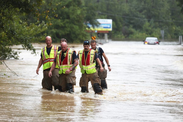
Tens of thousands of homeowners flooded by Hurricane Sally face potentially large financial losses because the federal government lists them improperly as living outside a flood zone and does not require them to have flood insurance.
The major flooding caused by Sally this week exposes flaws in the Federal Emergency Management Agency’s maps of the nation’s floodplains—flaws that lead homeowners to believe they do not face a significant flood risk and do not need flood insurance.
Sally made landfall along the Gulf Coast as a Category 2 hurricane Tuesday and was downgraded yesterday to a tropical depression. Flash flood watches were in effect from northern Georgia through the Carolinas into southeast Virginia. Roughly 500,000 customers remained without power in the Southeast.
On supporting science journalism
If you're enjoying this article, consider supporting our award-winning journalism by subscribing. By purchasing a subscription you are helping to ensure the future of impactful stories about the discoveries and ideas shaping our world today.
The storm caused major flooding in southern Alabama and the Florida Panhandle, largely because of rainfall as opposed to wind-induced storm surge. Near Pensacola, Fla., in the small town of Molino, more than 16 inches of rain fell in a 24-hour period, according to a U.S. Geological Survey gauge.
That’s a problem, said Jeremy Porter, chief researcher at the First Street Foundation, a New York City nonprofit that gained national attention this year by creating high-definition floods maps for the nation.
FEMA flood maps don’t account for all of the flooding caused by major rainstorms such as Hurricane Sally, which means that FEMA’s flood zones exclude properties vulnerable to rain-induced “pluvial” flooding, Porter said.
FEMA maps account for rainfall only to the extent that rain causes rivers and larger streams to overflow. The maps don’t include rainfall that causes flooding outside of streams, Porter said.
“They don’t take into account small creeks, tributaries and heavy pluvial events,” Porter said. “Unfortunately for homeowners in this area, that’s going to drive a lot of the [recent] flooding, because it’s heavily pluvial.”
Sally’s slow movement over Gulf Coast states enabled it to drop extensive rain, similar to how Hurricane Harvey soaked Texas in 2017 and Hurricane Florence drenched North Carolina in 2018.
The National Hurricane Center said Wednesday that Sally’s slow progress would create “a long period of heavy rainfall and historic flooding along the north-central Gulf Coast.”
“Sally sat over that area for two days. That’s exactly what Harvey did,” Porter said.
FEMA flood maps are crucial because many property owners who live in a high-risk flood zone are required under federal law to have flood insurance. People outside flood zones have no requirement and typically do not buy flood coverage. Flood insurance is sold separately from homeowners’ insurance policies, which do not cover flood damage.
The First Street Foundation’s flood maps, released in June to national acclaim, highlighted the problem with FEMA’s maps by accounting for rain-related flooding.
The result was that First Street found 14.6 million U.S. properties face a 1% annual chance of being flooded. FEMA maps show only 8.6 million properties facing a 1% annual chance of flooding.
In the area hit by Hurricane Sally, nearly 250,000 properties are in First Street’s flood zones but not in FEMA’s flood zones, according to an E&E News analysis of First Street data. E&E News analyzed the 162 counties in Alabama, Florida, Louisiana and Mississippi in which FEMA declared an emergency on Monday and Tuesday.
In Mobile County, Ala., on the Gulf Coast, FEMA lists 22,000 properties in a flood zone, while First Street found 39,000 properties face a significant flood risk.
In Santa Rosa County, Fla., FEMA lists 10,900 properties in a flood zone, but First Street found 17,100 properties face a significant flood risk.
FEMA has acknowledged shortcomings with its flood maps and said publicly that the maps give many people a false sense that they are protected from flooding if they are shown to be outside a flood zone. The agency is refining the maps to capture flood risk more accurately.
In a statement to E&E News yesterday, FEMA Deputy Associate Administrator David Maurstad, who runs the agency’s mapping program, said: “It’s important to recognize what FEMA flood maps are and what they are not. The flood maps are not predictions of where it will flood, and they don’t just show where it’s flooded in the past. The flood maps are snapshots in time of risk designed to show minimum standards for floodplain management and the highest risk areas for flood insurance.”
Maurstad noted that FEMA works with states and municipalities to incorporate local knowledge and data into flood maps.
“At any time, community officials can submit scientific or technical data to FEMA to support a local map revision,” Maurstad said. “Hurricanes do not follow lines on a map. Where it can rain, it can flood.”
Porter agreed with the agency. He said FEMA shows flood zones to help communities decide where development should occur. First Street shows individual property owners their flood risk to help them decide whether to take mitigation steps.
“They’d love to do some of the stuff we’re doing,” Porter said of FEMA.
Reprinted from Climatewire with permission from E&E News. E&E provides daily coverage of essential energy and environmental news at www.eenews.net.