
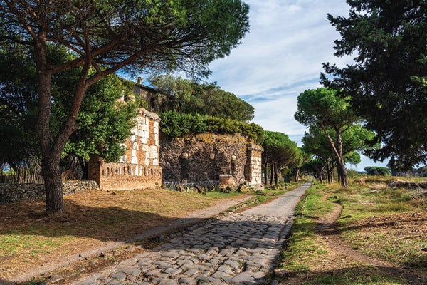
On a recent visit to Rome I walked along the Via Appia (also called the Appian Way), past the presumed house of Stoic philosopher Seneca, and felt transported in time. Constructed starting in 312 B.C.E. to carry troops southeast toward Capua and, eventually, the port city of Brindisi in the heel of Italy’s boot, the Via Appia is the oldest and best-known road of the Roman Empire.
Scholars have long regarded it as the quintessential Roman road: a straight highway extending as far as the eye can see, paved with slabs of volcanic stone, lined with pointy cypress trees and, of course, connecting to Rome. It is amazing to know that Romans walked here more than 2,300 years ago. No wonder this marvel of ancient engineering—long stretches of which remain remarkably intact today—is known as the Queen of Long-Distance Roads.
But iconic as it is, the Via Appia is not the archetype researchers have assumed it to be. My colleagues and I have produced a new map of Roman roads that, for the first time, reveals their locations at high resolution in a single, open resource. What we found revolutionized our view of the road system that undergirded this superpower of the ancient world.
On supporting science journalism
If you're enjoying this article, consider supporting our award-winning journalism by subscribing. By purchasing a subscription you are helping to ensure the future of impactful stories about the discoveries and ideas shaping our world today.
Historians and archaeologists have been studying Roman roads for centuries. In that time, they have found remnants of the roads themselves, crumbling milestones, and historical texts about major connections between settlements. But efforts to plot the roads based on these piecemeal sources yielded a low-resolution map of the Empire with approximate locations rather than precise ones.
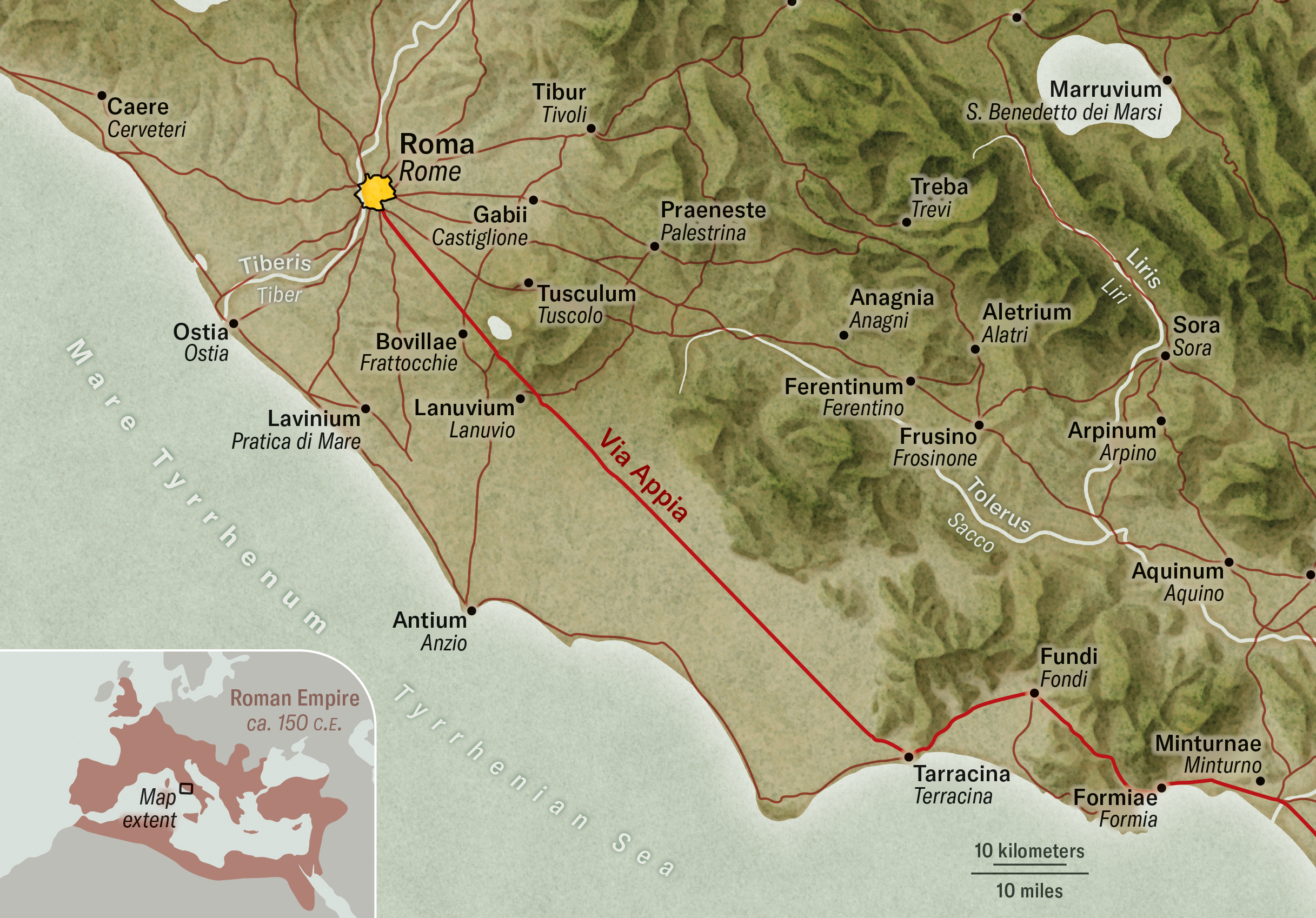
Click on the map for a closer look. Built to transport the Roman army south to expand the Empire’s influence, the Via Appia, a portion of which is shown here, connected Rome to Brindisi on the Adriatic coast.
Daniel P. Huffman
Knowing the location of Roman roads matters for understanding how the Empire conquered and pacified new territories and transported food to keep its people alive. Their development meant that for the first time in history, an area the size of the European Union was covered by a network that allowed the flow of people, goods, ideas and disease from Egypt to Germany, Spain to Turkey. To that end, my team and I set out to build the first high-resolution digital map of the Empire’s roads, combining information from historical datasets with modern topographical maps and satellite data, among other sources. We expected that 200 years’ worth of research tradition would allow us to simply connect the data points our predecessors had collected. We were wrong.
Our research implies that in the second century C.E., the period when the Empire had its maximum extent, this road network comprised some 300,000 kilometers—nearly double the previously known total length of Roman roads. This is a massive discovery. It’s also very humbling because despite seeing the full scope of the network, we know the precise location of only 2.7 percent of it. (The preserved sections of the Via Appia are part of this well-known minority.) How, after centuries of research, can we know so little about this system? And where are the lost roads of the Roman Empire?
Let’s start with what we do know. The ancient Romans invented far fewer things than they are often credited for, and they certainly did not invent the road. Rome’s strength lay in its ability to recognize a good idea and scale it to the size of a continent.
The generals and emperors of Rome conquered regions that already possessed elaborate road systems connecting densely urbanized areas. In the east, the Hellenistic kings who succeeded Alexander the Great had built many cities, such as Antiochia, and connected them with roads just as the Persians, Assyrians and Babylonians had done before them. The Achaemenid Persians even built a “highway” between their capital in Persia, Susa, and Sardis in western Turkey, known as the Royal Road.
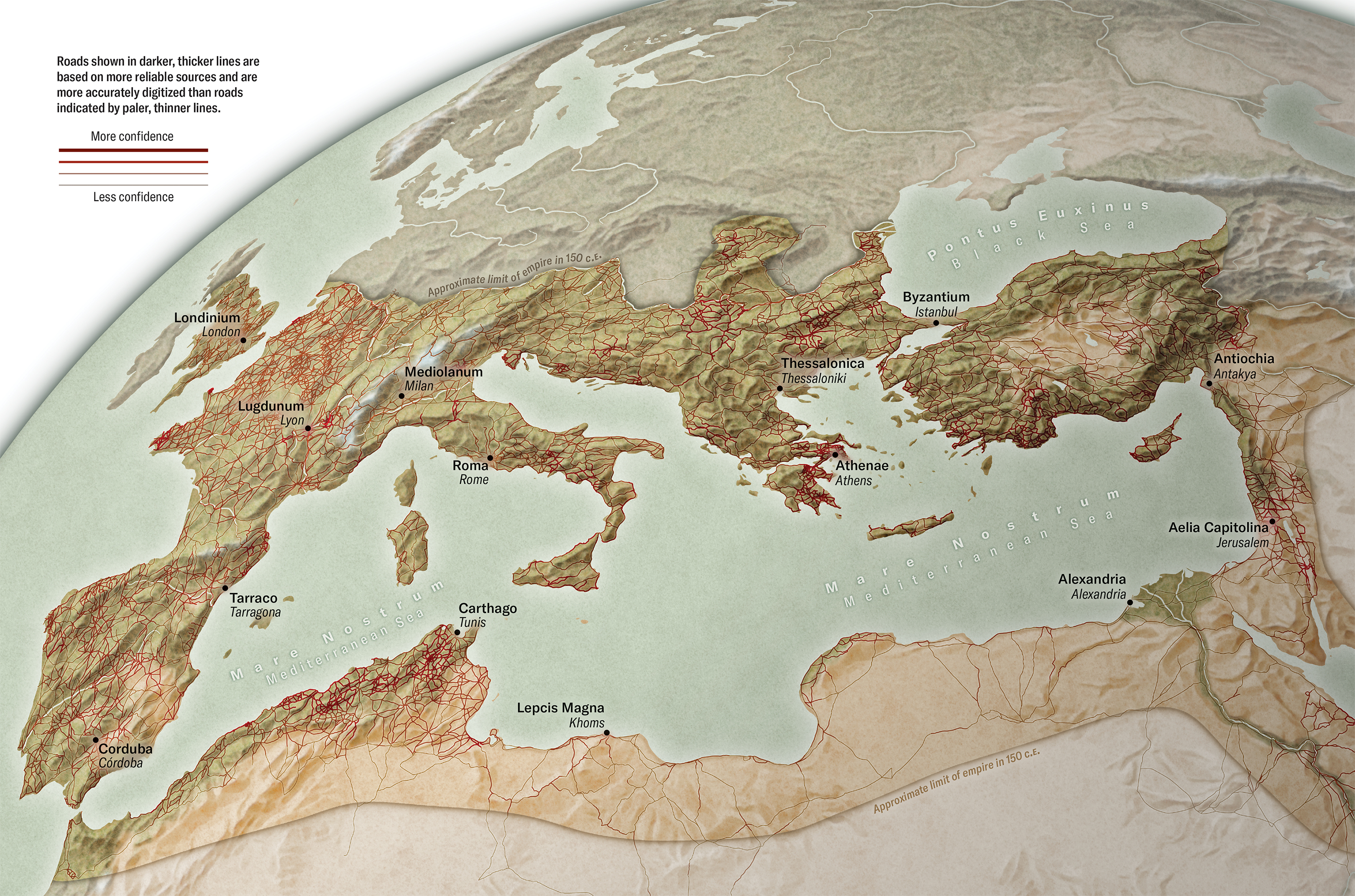
Click on the map for a closer look. In developing our digital atlas of Roman roads, we found 8,000 kilometers of roads whose location we know with certainty and 292,000 kilometers of roads that rely on varying degrees of conjecture. We created a confidence map that describes variation in the reliability of our sources and the accuracy of our digitization. It offers archaeologists a detailed guide to where to search for Roman roads.
Daniel P. Huffman
The Romans’ real innovation was the integration of these disparate local road systems into the first continent-scale road network in human history. And contrary to the proverb, they didn’t all just lead to Rome. Massive infrastructure projects purposely linked up the roads of different provinces into a connected whole, unlocking access to far-flung regions from the Atlas Mountains in Morocco to the Danube delta.
For instance, Roman emperor Trajan’s takeover of the Nabataean kingdom, centered in what is now Jordan, moved the Empire’s frontier to the Arabian Desert. His legions built the road known as the Via Nova Traiana, which ran from the Red Sea port of Aqaba to Bosra in Syria. This major Roman road does not lead to Rome. It was crucial infrastructure for the defense of the Empire and the mobility of its soldiers, connecting several eastern provinces. It formed part of the Limes Arabicus, a massive, 1,500-kilometer desert frontier with forts, which dwarfed Hadrian’s wall, the 117-kilometer frontier in Britain.
Much of what scholars have pieced together about such infrastructure projects comes from milestones. Like the mile markers along modern highways, these engraved stones informed travelers of their location and distance. The earliest known Roman milestone comes from Sicily and was erected by the consul C. Aurelius Cotta (who was consul in 252 and 248 B.C.E.) following the Roman victory over Carthage in the first Punic War. The Romans implemented this system across the entire Empire.
Milestones were more than just navigational aids: they were propaganda, often inscribed with the name of the emperor or local magistrates who funded the construction or renovation. In Spain, for instance, Augustus, the first Roman emperor, ordered the construction of the Via Augusta, a massive arterial route stretching from Cádiz in the south to the Pyrenees Mountains in the north. His name could be read on milestones dotting the entire stretch. The road plugged the people and economy of the Iberian Peninsula more tightly into the rest of the Empire.

The Arc de Berà, a Roman monument, was built in 13 B.C.E. along the Via Augusta in the Catalonia region of Spain. Today it overlooks the N-340, one of many modern European roads that have been constructed where Roman roads once stood.
RichSTOCK/Alamy
For our team, these milestones provided a crucial puzzle piece to our effort to locate missing Roman roads. The word “mile” comes from the Latin mille passus, which means 1,000 paces, the length of a Roman mile. A Roman pace was five Roman feet, so the Roman mile was 5,000 Roman feet and equaled about 0.92 of a modern English statute mile, or 1.48 kilometers. In our work milestones served as ancient GPS markers. For example, in the Middle East the discovery of two specific milestones was instrumental in identifying how a Roman road climbed from the Sea of Galilee to the plateau above.
The practice of cataloging inscriptions on milestones is more than a century old. Our breakthrough came from a more recent revolution in the field of archaeology: digitization. By aggregating databases that include more than 8,000 milestone locations and 14,000 ancient places, we were finally able to play a continent-scale game of connect the dots.
But connecting the dots with certainty is possible only if you can see the lines. And for the vast majority of the Roman network, those lines have vanished. We had to do a lot of detective work to reveal them.
Samosata, in present-day southeastern Turkey, was the capital of the kingdom of Commagene until it was incorporated into the Roman Empire in the first century C.E. We wanted to find its roads. Sadly, people can no longer visit this ancient city, because it was submerged under dozens of meters of water after construction of the Atatürk Dam on the Euphrates River in the 1980s. The dam inundated Samosata, along with an area of more than 800 square kilometers (equivalent to some 112,000 soccer fields). But cold war–era satellite photography aided our search. We were able to find traces of ancient roads in these declassified images, which were taken before the reservoir was flooded.
It’s not just dams that led to the destruction of roads. Population growth in a region requires the development of plots of lands for housing. Digging foundations destroys traces of past human activity, and it is not always possible to excavate before destruction. In these situations, historical satellite photography can act as a kind of time machine that allows us to examine a landscape as it was before urbanization. In the images, we can see traces of roads long since destroyed—true lost Roman roads.
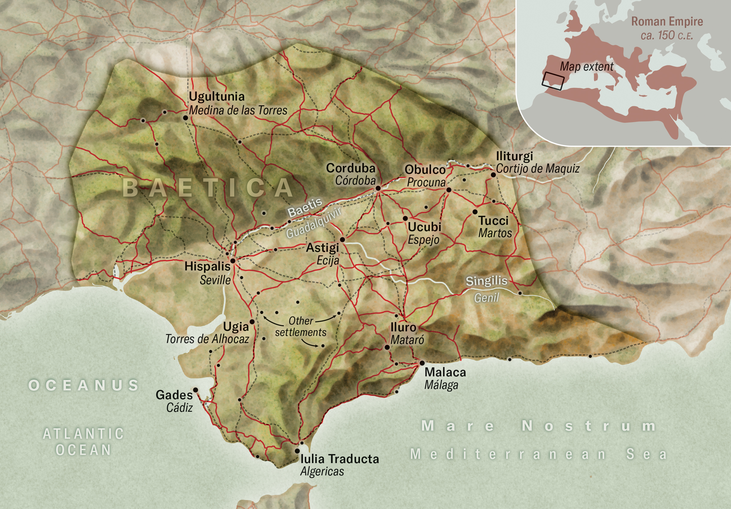
Click into the map for a closer look. The province of Baetica in Spain was a hub for the production of olive oil, which was vital to the success of the Roman army. Archaeologists know the exact locations of many structures and settlements in the region (small black dots) but not the roads that must have connected them.
Daniel P. Huffman
Historical satellite photography is not our only tool for peering into the past. Detailed topographic maps—a common by-product of wars—can also reveal landscapes as they looked before extensive development. For instance, France controlled Syria and Lebanon between the two world wars, and its army created detailed maps of these territories in that period. On the interbellum-era French military maps, we can clearly see a line labeled as a Roman road in Bosra in Syria, that is now partly covered by suburban development.
These detailed landscape sources also allowed us to map the roads more precisely by taking the topography into account. The previous reference work for the entire Roman Empire was the Barrington Atlas of the Greek and Roman World, published 25 years ago. This mammoth work was foundational for creating an integrated picture of roads and places in the ancient world. It was subsequently digitized and remains the only such resource for the Empire as a whole. But its maps are at 1:500,000 or 1:1,000,000 scale—that is, one inch on the map would reflect 7.89 miles or 15.78 miles on the ground, respectively—resulting in roads that do not conform to the shapes of the landscape.
In this atlas, a mountain stands between the ancient Greek cities of Mantinea and Argos near Mycenae on the Peloponnese Peninsula. A 62-kilometer-long road winds around the mountain, a route it would take roughly 20 hours to walk. Ancient hikers had another option, though: cross the mountain passes, which cut the trip down to 14 hours. We mapped the sharp switchbacks that characterize such mountain hikes. A map this detailed shows lots of zigzags, which is one of the reasons we ended up extending the Roman road network by a staggering 111,000 kilometers. We can be certain that 300,000 kilometers is much closer to its actual length, considering the complexities of the terrain.
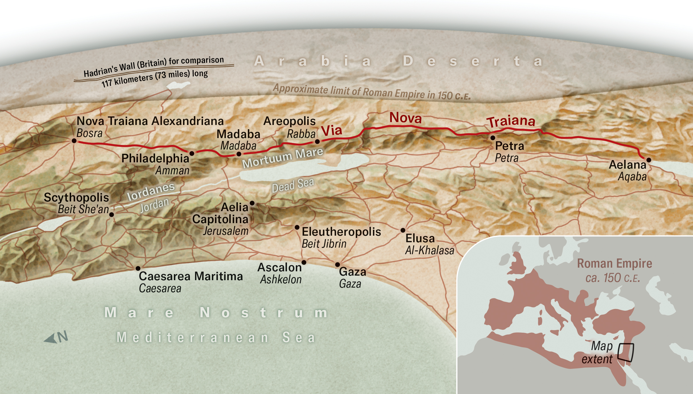
Click on the map for a closer look. Not all major Roman roads lead to Rome. The Via Nova Traiana ran from the Red Sea port of Aqaba to Bosra in Syria. It formed part of a massive desert frontier with forts.
Daniel P. Huffman
In addition to consulting historical satellite photography and topographical maps, we used the tools of paleogeography—the reconstruction of ancient landscapes through studies of their sediment profiles, among other factors—to guide our search for Roman roads. We know that landscapes changed significantly in the deltas of the region’s major rivers. The Rhine and Meuse Rivers merged in the southern Netherlands into a historically transforming landscape of wetlands, marshes and islands as the rivers changed their courses. The Dutch famously canalized much of their country, including large sections of the rivers, even turning their ability to control the flooding of riverine wetlands into a weapon against Spanish invaders in the 17th century. This history also means the delta landscape we see today bears little resemblance to the situation 2,000 years ago. The Dutch members of our team turned to existing reconstructions of the riverine landscape as it was in Roman times to identify old, abandoned riverbeds and thus locate the dry land between settlements that could have supported roads.
We can be certain of road locations only if parts of the path have been excavated or are still visible in the landscape, as is the case for the Via Appia. Archaeologists have excavated sections of roads all over the Roman Empire’s territory and surveyed expansive landscapes in search of such traces. But excavation is expensive and time-consuming. It is usually carried out as a direct reaction to development and tends to focus on point locations such as villas or milestones. Excavating a long linear feature over vast landscapes is simply not easily done. For this reason, we know much more about the settlements and farms where the Romans lived than we do about the roads that connected them.
Take the province of Baetica in the south of Spain, for instance. It was crucial for the success of the Roman legions. Huge surpluses of olive oil were produced in the Guadalquivir river valley there. Olives were transported over roads from the groves to the presses where their oil was extracted and bottled into enormous, globular ceramic amphora containers, which were then shipped down the river and across the seas to the Roman army as far afield as Germany. This part of the Empire was densely occupied, and we know the locations of hundreds of farms, presses, ceramic kilns, river ports and settlements. But zooming into our map reveals that some of these landlocked places were not connected by a known road. There are many such places throughout the Empire that must have been connected by roads of some form or other for their inhabitants to reach their homes or olive groves.

The Romans used milestones, such as this one on the Via Domitia in Herault, France, across the Empire to inform travelers of their location and distance. These stone markers can be used to reconstruct the paths of Roman roads.
Hemis/Alamy
We found 8,000 kilometers of roads for which we know the location with certainty. That’s roughly the distance of a drive from Paris to New Delhi over modern roads. The remaining 292,000 kilometers (equivalent to seven times the circumference of Earth) of roads on our map rely on varying degrees of conjecture. We may have ancient written sources indicating there was a Roman road in a particular region, for example, but limited information about where in the landscape it ran.
As researchers, we must be open and explicit about what is observed and what is informed conjecture. That is why we created a confidence map that describes variation in the reliability of our sources and the accuracy of our digitization. It essentially charts our ignorance. This approach gives archaeologists the first detailed guide to where future searches for Roman roads are likely to reap the greatest rewards.
Tens of thousands of kilometers of roads remain to be discovered. Our publicly available online atlas, called Itiner-e, reveals where to look for them. And it is working. Since its launch, we have received pointers from around the globe to help us find these lost thoroughfares of the Roman Empire. The search is on for the roads that changed the world.
