
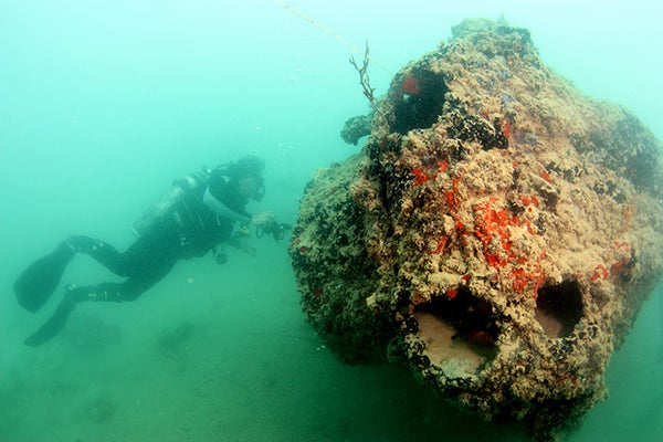
For the first time, archaeologists have been able to map and image the sunken fleet of seaplanes destroyed in a prelude to the Pearl Harbor attack 74 years ago. To commemorate the anniversary, the National Oceanic and Atmospheric Administration (NOAA) and the University of Hawaii (U.H.) have released rare images of one of the sunken planes today.
The Empire of Japan’s attack on the U.S. naval base in Pearl Harbor, Hawaii, killed 2,403 U.S. personnel, destroyed 169 aircraft and sunk 19 ships. Although, the harbor’s sunken ships, where a rainbowlike sheen of ever-leaking oil reflects off the water’s surface, mark a unique memorial themselves, many forget that remnants of the attack also lurk in a nearby bay.
Minutes before attacking Pearl Harbor, Japanese aircraft bombed the nearby U.S. Naval Air Station on the east coast of Oahu, about 20 kilometers from Pearl Harbor. The Japanese air force successfully destroyed 27 and damaged six Catalina PBY-5 aircraft—common seaplanes used during World War II—on the ground and in Kāne‛ohe Bay. It was a significant loss for the U.S. military because the station had lost all its long-range bombers capable of following the attackers. In fact, damages were so extensive that only three aircraft out on patrol were fit to fly by the end of the attack.
On supporting science journalism
If you're enjoying this article, consider supporting our award-winning journalism by subscribing. By purchasing a subscription you are helping to ensure the future of impactful stories about the discoveries and ideas shaping our world today.

The starboard engine nacelle (housing) extending into the silt. Credit: UH Marine Option Program
Since 1994 U.H. has made several efforts to map and take images of the sunken wreck but has been deterred because of murky water that limits visibility. Last June, thanks to better equipment and higher visibility, students from the University of Hawaii Marine Option Program—a field school that teaches students how to survey shipwrecks underwater—were able to map the entire site and produce the first systematic photos and video documentation. The images released today document one of the seaplanes that sunk during the opening minutes of the first attack. It’s now clear that it rests in three large pieces nine meters beneath the surface. Although its precise identity remains unknown, the team speculates that it was likely attempting to take off in the face of the attack.
"The new images and site plan help tell the story of a largely forgotten casualty of the attack," Hans Van Tilburg, a maritime archaeologist with NOAA and the team’s coordinator, said in a statement. "The sunken PBY plane is a very important reminder of the 'Day of Infamy,' like the [battleships] USS Arizona and USS Utah. They are all direct casualties of December 7."

Cockpit detail showing portside wheel and throttle controls (left) extending downward (to the right) from the overhead. Credit: UH Marine Option Program