
President-elect Joe Biden said Saturday he’ll put climate change at the top of the Biden-Harris administration.
The climate responded with Tropical Storm Eta, the record-tying 28th named storm of the 2020 hurricane season and the first to bring high winds, torrential rain and flooding to Florida this year.
Experts say Eta, which could make two landfalls in the Sunshine State by week’s end, put an exclamation point on science-based warnings that tropical systems will grow wetter and more destructive as the climate warms.
On supporting science journalism
If you're enjoying this article, consider supporting our award-winning journalism by subscribing. By purchasing a subscription you are helping to ensure the future of impactful stories about the discoveries and ideas shaping our world today.
And Eta almost certainly will be the 17th climate disaster this year with damages of at least $1 billion.
That’s nearly four times larger than the fiscal 2020 budget of NOAA, whose primary goals include “reducing the impacts of extreme weather and water events to save lives and protect property.”
Eta broke records in other ways, too. It was the 12th named storm to strike the United States in a single hurricane season, toppling the previous record of nine storms in 1916. If it restrengthens into a hurricane this week in the Gulf of Mexico, it would become the seventh U.S. land-falling hurricane in a calendar year, a record, according to NOAA’s National Centers for Environmental Information.
From 1851 through 2019, the U.S. averaged 3.2 land-falling storms per year and 1.6 hurricane-strength landfalls, according to NOAA.
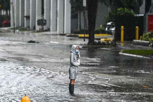
Yesterday, 65-mph winds and rain pounded Florida’s lower peninsula after Eta made landfall at Islamorada, about 17 miles south of Key Largo. Emergency officials reported overwhelmed sewers and drainage canals in southwest Florida, with up to 3 feet of water backing up into streets from Miami-Dade to Fort Lauderdale.
The National Weather Service reported nearly 18 inches of rainfall in Pembroke Pines, a Broward County city of 180,000 on the edge of the Everglades. “In some areas, the water isn’t pumping out as fast as it’s coming in,” Miami-Dade County Commissioner Jose “Pepe” Diaz told the Orlando Sentinel yesterday morning.
In Monroe County, which includes the Florida Keys, officials warned of major saltwater flooding across roads and low-lying areas on the bayside of Key Largo. “Storm drains will overflow, and many sea walls and docks will be overtopped,” Monroe County Emergency Management said.
The Army Corps of Engineers, which had been diverting water from Lake Okeechobee since mid-October due to high water levels, could see substantial inflows over the next several days as Eta soaks areas immediately north of the lake. A breach or overtopping of Okeechobee’s earthen dike could trigger massive flooding in the Everglades.
Eta had already killed more than 100 people in Costa Rica, Guatemala, Honduras, Nicaragua and Panama after landing in Central America as a Category 4 storm one week ago.
The National Hurricane Center reported at 4 p.m. EST yesterday that the storm was moving west at 16 mph as an upper-level, low-pressure system pushed the storm’s center over the Gulf of Mexico. It was expected to see “little overall motion” today followed by a slow northward motion overnight into tomorrow.
Eta could modestly strengthen over the next 24 hours, forecasters said, with an additional 12 to 18 inches of rain possible over peninsular Florida today and tonight, NOAA said.
Remarkably, Eta was the first named storm to directly hit Florida this year. Category 2 Hurricane Sally, which landed at Gulf Shores, Ala., did extensive damage in nearby Pensacola and the westernmost Florida Panhandle (Climatewire, Sept. 16).
By contrast, Louisiana had five land-falling storms through Oct. 30.—Cristobal, Marco, Laura, Delta and Zeta. Laura, a Category 4 hurricane, brought 150-mph winds to Cameron, La., tying a record from 1856 (Climatewire, Aug. 28). Six weeks later, Hurricane Delta made landfall at Creole, La., just 13 miles east of Cameron.
Philip Klotzbach, a meteorologist at Colorado State University and expert on Atlantic basin hurricanes, said on Twitter that the first nine days of November saw 15 “accumulated cyclone energy” events, an integrated metric accounting for intensity and duration of tropical storms. The last time that happened was in 2001, and it has occurred only four times dating back to 1896.
Josh Alland, a hurricane expert at the National Center for Atmospheric Research in Boulder, Colo., noted that Eta was the ninth storm this year to “rapidly intensify,” with wind speeds increasing 70 mph over 24 hours. Research has shown that rates of intensification may increase under warming climate conditions, he said.
Reprinted from Climatewire with permission from E&E News. E&E provides daily coverage of essential energy and environmental news at www.eenews.net.
