
On supporting science journalism
If you're enjoying this article, consider supporting our award-winning journalism by subscribing. By purchasing a subscription you are helping to ensure the future of impactful stories about the discoveries and ideas shaping our world today.
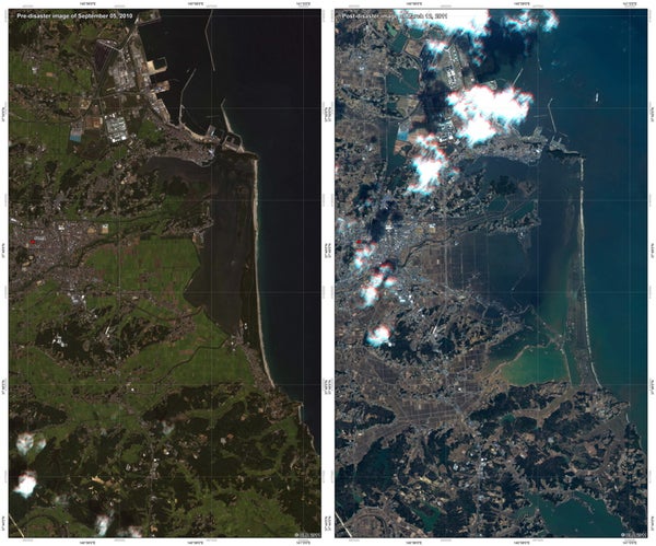
When devastation extends as far as the human eye can see, digital eyes in the sky can provide essential information for emergency response efforts. These satellite images show the town of Soma (red dot) and surrounding area on Japan's northeastern coast as they appeared on September 5, 2010, [left] before the March 11, 2011, earthquake and tsunami, and on the day after.
On the heels of the earthquake, tsunami heights of 7.3 meters were reported in Soma. A day later floodwaters stretched several kilometers inland. Soma is a port village of 38,000 people located about 150 kilometers southwest of the magnitude 9.0 quake's epicenter and 40 kilometers north of the stricken Fukushima Daiichi nuclear power plant. As of March 20, more than 100 residents of Soma have been confirmed dead.
These satellite images were provided by the International Charter—Space and Major Disasters, a 20-member multinational agreement among space agencies and other organizations that operate satellites to contribute data to aid the management of large-scale natural disasters and technological accidents. The organization is on 24-hour alert and can be activated by a phone call from any of the member agencies and other authorized organizations. The Charter was activated on March 11 on request of the Japan Aerospace Exploration Agency; the images here were shared by the German Aerospace Center.
Since its founding in 2000 the International Charter has provided satellite images of 289 disasters, including the recent earthquakes in Pakistan and Haiti as well as the 2010 massive oil spill in the Gulf of Mexico.
—Nina Bai
