
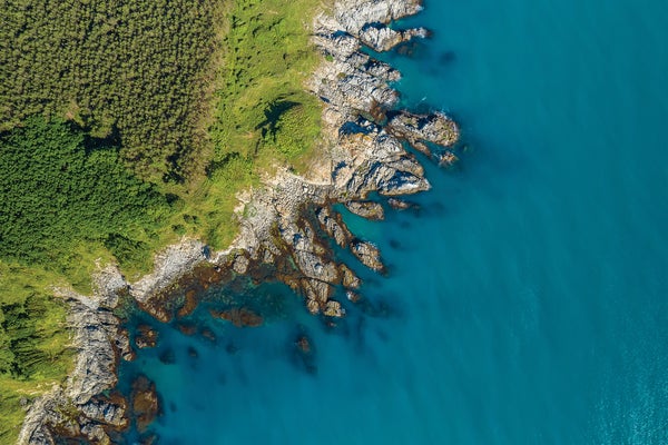
In 1967 mathematician Benoit Mandelbrot observed that the coastline of Great Britain is impossible to measure—its perimeter gets longer the more closely you measure it. At that point he was eight years away from coining the term “fractal”: a shape containing smaller parts similar in shape to the larger whole that become apparent as you zoom in, creating an infinite, and infinitely complex, repeated pattern. Now the so-called coastline paradox he observed is one of many known examples of fractals in Earth’s geography. But recent work has found that coastlines may actually be far less fractal than thought.
The research, published on the preprint server arXiv.org and accepted in Geophysical Research Letters, stitches together geographic data for more than 130,000 of Earth’s islands to show that although the landmasses behave like fractals in certain respects, the extent to which they do—their fractal dimension—differs depending on what geometric feature of the island you’re looking at. Coastlines, researchers found, come in last (after, for instance, surface elevation). This discovery is a departure from current fractal models of Earth’s surface, according to University of Chicago mathematician Matthew Oline, the study’s lead author.
A shape’s fractal dimension tells you how much you can zoom in to keep the fractal pattern repeating. An island coastline with a low fractal dimension might look almost completely smooth, whereas one with a high fractal dimension will have a visibly bumpy, complex border even as you zoom in further. This concept extends to other geometric features of islands, including size distribution, elevation and volume. For example, small islands are far more abundant than large ones—a pattern of complexity that makes the distribution of sizes for Earth’s islands fractal, too. In typical models of Earth’s surface, all features scale with the same fractal dimension.
On supporting science journalism
If you're enjoying this article, consider supporting our award-winning journalism by subscribing. By purchasing a subscription you are helping to ensure the future of impactful stories about the discoveries and ideas shaping our world today.
Oline found, however, that some island features can handle more zooming in than others on their fractal detail. He says this result isn’t remarkable, because existing fractal models are more like “toy models” than an exact representation of Earth. What was unexpected, though, was the stark difference between the different geometric features’ fractal dimensions—especially for the surprisingly smooth coastlines. “The coastline paradox is the one people have heard of, but actually, the coastlines are the smoothest feature we see here,” Oline says. This finding aligns with the idea that factors such as sedimentation and erosion would chip away at a coastline’s complexity more than, say, a mountaintop’s.
Andreas Baas, a geomorphologist at King’s College London who was not involved with the work, was also surprised by how smooth coastlines are compared with previous studies’ estimates. He says the authors’ approach to calculating the fractal dimensions was “very rigorous,” but he is more cautious about attaching meaning to the differences. Their hypothesis opens up “new avenues for research” to close existing gaps between studies involving coastline and surface models, Baas says. “It would be interesting to combine these models to see whether they can reproduce observed [fractal] relationships.”
