
It’s been two years since El Niño wreaked havoc across the globe. The climate pattern, which takes place as a result of changes in the Pacific Ocean, drove heavy rainfall along the western U.S. and drought in Southeast Asia, and brought with it some of the highest global temperatures ever recorded. And this year United Nations forecasters predict the climate phenomenon could return—but, they caution, it’s still too early to tell for certain.
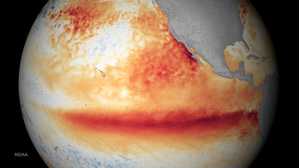
El Niño’s power rests in a combination of ocean temperatures and wind. During El Niño events, warm ocean water moves from the western Pacific toward North and South America. The changes in ocean temperatures can set off a string of weather impacts across the globe—for instance, it can mean heavy rains in the southern U.S., while regions on the other side of the Pacific tend to dry out. Its opposite, La Niña, tends to cause cold, wet weather in the northern U.S., a more active Atlantic hurricane season and more rainfall in parts of Asia and Australia.
These patterns tend to oscillate—the last La Niña is ongoing but weak. And on Tuesday the World Meteorological Organization (WMO) announced there is a moderate chance that El Niño will return in 2026.
On supporting science journalism
If you're enjoying this article, consider supporting our award-winning journalism by subscribing. By purchasing a subscription you are helping to ensure the future of impactful stories about the discoveries and ideas shaping our world today.
According to the WMO, chances of El Niño are around 40 percent between May and July this year. The predictions are preliminary and could change. Predicting whether this will be an El Niño year so far in advance is tricky, in part because global climate patterns are complicated and because it’s still early.
The National Oceanic and Atmospheric Administration (NOAA) currently puts the chances of an El Niño forming at about 50 to 60 percent for the late summer, although those predictions are also subject to change.
NOAA classifies El Niño and La Niña events in part by looking at average temperatures in a patch of the Pacific Ocean: If the temperatures exceed 0.5 degrees Celsius above normal for an extended period, those are El Niño conditions. If they drop 0.5 degrees Celsius below normal, it’s La Niña.
But even with all the uncertainty, an early heads-up that El Niño is coming can be valuable to countries so that they can prepare for the weather that comes with it. The predictions are intended to manage disaster risk—and ultimately, save lives, said Celeste Saulo, the WMO’s Secretary-General, in a statement.
“Seasonal forecasts for El Niño and La Niña help us avert millions of dollars in economic losses and are essential planning tools for climate-sensitive sectors like agriculture, health, energy and water management,” Saulo said.
