
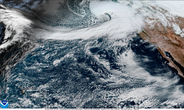
A “bomb cyclone” is bringing damaging winds to parts of the U.S. Northwest and northern California today, and the storm is helping to set up powerful atmospheric river that one weather experts says will open a “firehose” of rain and snow onto parts of the West Coast. Northern California will be particularly hard-hit by extreme rainfall rates.
The term bomb cyclone refers to an area of low atmospheric pressure that suddenly “deepens,” or drops even further in pressure. This process, called bombogenesis, happens when a storm system’s pressure falls by a certain amount within 24 hours, based on the system’s current latitude. At a latitude of around 45 degrees North, bombogenesis occurs when pressure drops by at least 18 to 20 millibars. This storm will easily clear that hurdle, dropping between 60 and 70 millibars in 24 to 36 hours, wrote climate scientist Daniel Swain in a recent post on his blog. “This will likely be among the fastest if not the singularly fastest-deepening low pressure system on record in this region,” he added.
The storm will bring winds up to 70 miles per hours to parts of Washington State, Oregon and California, where it could knock out electricity and damage trees, according to the National Weather Service. Blizzard conditions are forecast for Washington’s portion of the Cascade Range.
On supporting science journalism
If you're enjoying this article, consider supporting our award-winning journalism by subscribing. By purchasing a subscription you are helping to ensure the future of impactful stories about the discoveries and ideas shaping our world today.
A front (essentially the boundary between two air masses with different temperatures and humidities) associated with the bomb cyclone is expected to stall near northern California on Wednesday, and that will set up a stream of water vapor called an atmospheric river. Such streams can be up to 2,000 miles long, 500 miles wide and two miles high, with a flow of moisture 25 times that of the Mississippi River. This atmospheric river will be pulling tropical moisture from around Hawaii and sending it over to the West Coast in in several waves of heavy to extreme precipitation, particularly in mountainous areas. It is a bit uncertain which areas will get the biggest impacts because the river can “wiggle” up and down along the coast, as Swain put it on his blog.
He also noted that this atmospheric river will likely pull in even more water vapor because of unusually high ocean temperatures along its path.
Though atmospheric rivers are crucial to supplying the winter precipitation that later provides water to the largely arid West during the dry season, the torrential nature of such rains can also be dangerous. They can cause mudslides and flash flooding—hazards that are particularly of concern near the burn scars of wildfires because the scorched soil cannot soak up the onslaught of water, raising the risk of landslides.