
Each year, June 1 marks the beginning of the Atlantic Ocean’s hurricane season, the time when the environmental ingredients come together for these powerful, destructive storms to develop.
But of course, the storms don’t know the calendar. Tropical cyclones—the blanket term for hurricanes, tropical storms and typhoons—can form outside of this window, and even in the most active years, hurricane season is never a constant stream of storms.
That’s particularly true of the Atlantic Ocean, where the season lasts six months (until November 30) but most tropical cyclones form in only three: August, September and October. “There’s kind of a tight window when the Atlantic goes bananas,” says Phil Klotzbach, an atmospheric scientist at Colorado State University. “There’s a lot of time where there’s not necessarily a lot going on.” By August 15—more than two months into the season—the Atlantic, on average, produces only one hurricane, he notes.
On supporting science journalism
If you're enjoying this article, consider supporting our award-winning journalism by subscribing. By purchasing a subscription you are helping to ensure the future of impactful stories about the discoveries and ideas shaping our world today.
READ MORE: How to Decode a Hurricane Forecast
So why does the season encompass those six months? There’s real science underlying the designation.
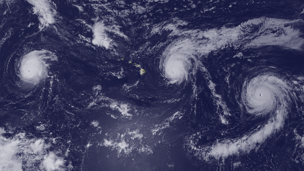
The key ingredients for a tropical cyclone to form are ocean surface temperatures of at least 80 degrees Fahrenheit (26 degrees Celsius), relatively little of what scientists call wind shear—the amount of variation in wind direction at different levels of the atmosphere, a phenomenon that can tear apart a growing storm—and plenty of humid air.
The warm waters alone are a significant limitation on cyclone formation. “That’s just not something that we see outside of hurricane season,” says Morgan O’Neill, an atmospheric physicist at the University of Toronto. To have all of these ingredients outside the official hurricane season is extremely rare—only 3 percent of Atlantic tropical cyclones have formed outside those six months.
To dig a little more into why conditions are only ripe at a certain time of year, let’s start with those sea surface temperatures: they rise and fall in response to local seasons, of course, but don’t do so immediately. Sunlight can warm only the uppermost water, and ocean water circulates vertically so quickly that cold water is always mixing in from below, meaning it takes a long period of regular sun exposure to warm the upper layer to the required temperature. That lag pushes the peak of sea surface temperature in the Atlantic from the mid-June solstice to mid-September.*
Next, consider wind shear. It is lowest in late August in the Atlantic because the tropics and subtropics are closest in temperature then—creating the ocean’s distinctive peak in tropical storm and hurricane activity. (The eastern Pacific is a little more prone to sizable storms in late May as a result of low-level wind patterns, hence its season beginning on May 15.)
Of course, “having the ingredients in place is necessary but not sufficient for a hurricane to form,” O’Neill says. A tropical cyclone can only develop around what scientists call a seed, an initial disturbance in the atmosphere that is able to grow into a massive storm. Such seeds turn out to be a limiting factor, with plenty of favorable environments never producing or supporting tropical cyclones.
This year’s Atlantic Ocean hurricane season has high odds of starting off even more quiet than usual, Klotzbach says. That’s because of the global climate phenomenon called the El Niño–Southern Oscillation, which scientists say is highly likely to shift into its El Niño phase within the next couple of months. During the El Niño phase, warm water around the Pacific equator spreads far to the east, typically changing patterns of wind shear to favor tropical cyclone activity in the eastern Pacific and decrease it in the Atlantic.
That pattern means that even though scientists expect the Atlantic to be somewhat warmer than normal, the National Oceanic and Atmospheric Administration’s official forecast for the Atlantic hurricane season puts the odds in favor of fewer storms. For Klotzbach, who also produces seasonal forecasts, the current Atlantic outlook is a relief—if the prediction holds, this will be the first year of below-average activity in a decade, he says.
But that shouldn’t mean complacency as the season unfolds. The total number of tropical cyclones matters much less than the number that make landfall—the ones most likely to kill people and damage property. And El Niño doesn’t prevent devastating storms—for example, 1992’s hugely destructive Hurricane Andrew occurred in an El Niño year. “It just takes one,” Klotzbach says.
*Editor’s Note (6/1/26): This sentence was edited after posting to correct the description of the mid-June solstice.
