
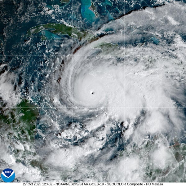
As of October 28, Hurricane Melissa is poised to devastate Jamaica this week as the slow-moving storm—which rapidly exploded into a major Category 5 hurricane over the preceding weekend—dumps huge amounts of rain on the Caribbean island, likely triggering flash floods and landslides. Some areas could see as much as 40 inches of rainfall in just a few days. With that depth, an Olympic swimming pool’s worth of water would cover scarcely less than half the area of a football field.
Winds are the threat that is most associated with hurricanes, followed by storm surge. But rain is an often overlooked peril of such storms—and can be the most dangerous one. That was the case with 2017’s Hurricane Harvey—which established the record for rainfall in a single storm in the continental U.S. when it dropped more than 48 inches of rain near Houston—and with last year’s Hurricane Helene—which dropped as much as two feet of rain in Appalachia just days after previous rainfall of approximately one foot in the region.
READ MORE: Hurricane Science Has a Lot of Jargon—Here’s What It All Means
On supporting science journalism
If you're enjoying this article, consider supporting our award-winning journalism by subscribing. By purchasing a subscription you are helping to ensure the future of impactful stories about the discoveries and ideas shaping our world today.
As of the morning of October 28, Melissa was a Category 5 hurricane with a peak sustained wind speed of 185 miles per hour after it underwent extreme rapid intensification over the weekend, according to the National Oceanic and Atmospheric Administration’s National Hurricane Center, which is operating despite the now three-week-long, continuing shutdown of the federal government. The storm could fluctuate in intensity as it approaches Jamaica but will remain a major hurricane, eventually hitting Cuba by the middle of the week. It is expected to later move out into the Atlantic and is unlikely to affect the U.S. mainland.
Even as the winds within Melissa have become incredibly powerful, the atmosphere around the storm has been calm, leaving it meandering through the Caribbean. Melissa’s eye is currently moving at a speed of three miles per hour. All of the threats of a serious hurricane are exacerbated when a storm moves slowly because any given place is exposed to hurricane conditions for more time. “Getting hit by a hurricane is never good,” says Brian McNoldy, a hurricane researcher at the University of Miami. “But getting hit by a hurricane that’s not moving is so much worse.”
As Melissa crawls by, it will dump huge amounts of rain on the islands in its path. The National Hurricane Center forecasts 15 to 30 inches of rain across parts of Jamaica and the southern areas of the island of Hispaniola, which is divided between Haiti and the Dominican Republic. Regions of Jamaica could see up to 40 inches. Rainfall forecasts for Cuba predict up to 20 inches.

Rainfall forecast for Hurricane Melissa.
NWS/NCEP Weather Prediction Center (WPC)
Life-threatening storm surge is looking increasingly likely for Jamaica, with peak heights of nine to 13 feet above ground level.
More intense rainfall events from storms of all kinds are becoming more likely as warming temperatures prime the atmosphere to hold more water vapor. “That is the fingerprint that climate change has on storms—in general, more moisture, more rain,” McNoldy says.
He worries that Melissa’s devastation in the Caribbean will be worsened by the mountainous terrain of islands such as Jamaica and Hispaniola. Such a landscape is particularly vulnerable to flash floods and landslides because water rushes to the lowest elevation it can find—consider the terrible flooding Hurricane Helene brought to Appalachia last autumn. In addition, mountainous landscapes can worsen rainfall itself because when an air mass hits a mountainside, it is forced upward, which causes it to drop more of the water inside of it, McNoldy says.
The combination could be a recipe for dire flash flooding, which is particularly dangerous in steep terrain that funnels huge amounts of water into small areas. “Once you’re over even half a foot of rain, it’s a ridiculous amount of rain,” McNoldy says. “When you’re getting into 12-plus inches of rain, it’s just too much for anywhere to handle, no matter how good your infrastructure is.”
Editor’s Note (10/28/25): This article was edited after posting to update the forecast for Hurricane Melissa.