
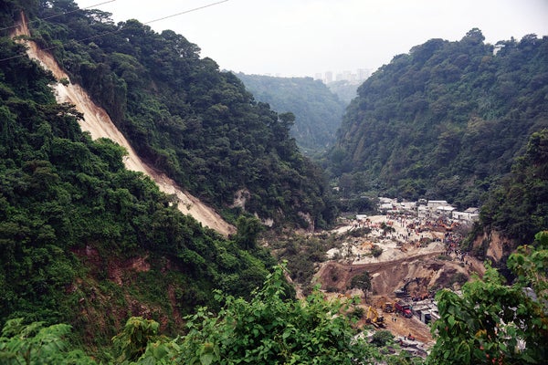
For several days in late September 2015, heavy rains soaked the earth surrounding the district of El Cambray II in Guatemala. On the first night of the following month, steep slopes, long held in place by thick, tropical tree roots, suddenly gave way, burying hundreds of homes in mud up to 15 meters deep. At least 280 people died.
Officials had warned residents for years that the area was at risk, but a mixture of poverty and mistrust leads some of the poorest people in Central America and beyond to build and live on marginal land. Still, residents of El Cambray II might have been willing to temporarily evacuate, if they had received a credible and precise warning. And if such warnings were available worldwide, they could help reduce the 3,000 deaths attributed to landslides every year.

Rescuers searching the following day for victims. Credit: Johan Ordonez Getty Images
On supporting science journalism
If you're enjoying this article, consider supporting our award-winning journalism by subscribing. By purchasing a subscription you are helping to ensure the future of impactful stories about the discoveries and ideas shaping our world today.
Fortunately, slide alerts worth heeding are in the works—and the El Cambray II event gave scientists their first new landslide data against which to validate a novel software system for monitoring the hazards in near real time. The basis is U.S. National Oceanic and Atmospheric Administration infrared and microwave satellite data, which enable a global forecast of rainfall at a four-kilometer resolution for up to six hours into the future. Scientists at the Hydrologic Research Center (HRC) in San Diego, who developed the system, add local weather radar and rain-gauge data where available to help predict likely flash floods. A new component for predicting landslides integrates global soil-moisture assessments. In Guatemala, local partners combine all these data onto a digital map of more than 8,000 known historic landslide sites to yield risk estimates as frequently as every six hours. The resulting landslide warnings focus on the effects of a specific storm on areas just two to four kilometers across. Such alerts are harder to ignore than blanket warnings, which might be in place for days or cover entire valleys, and may not account for local soil conditions.
Soil moisture is a key factor that can transform a flash flood into a landslide: a heavy storm assaulting already wet soil is riskier than the same storm falling on drier soil, says civil engineer Jacqueline Rivera of El Salvador's Ministry of Environment and Natural Resources, who also is testing the landslide-forecast system.
This is why El Cambray II was so important: it was the first event of its kind to occur after the landslide component was added to the flash-flood forecasts for validation. Once the storm had passed, researchers quickly saw that the enhanced system had identified El Cambray II as being at high risk for a landslide throughout the 2015 storm. The event also gave them an opportunity to closely study the postslide conditions on the ground and compare them with the satellite-based prediction. Landslide “nowcasts” are maturing elsewhere, too. Geomorphologist Dalia B. Kirschbaum of the NASA Goddard Space Flight Center and her colleagues published online a global system that integrates the agency's weather satellite data with a similar landslide-prediction model. NASA plans to use the system to aid humanitarian organizations such as the World Food Program and the International Committee of the Red Cross in disaster-response planning.
Meanwhile all seven Central American countries are calibrating how well the HRC landslide models mesh with local historical and real-time landslide data. Later HRC will use funds from the U.S. Agency for International Development to train civil defense officials in 57 more countries. Currently the models and their forecasts are shared only with disaster-management teams, but Rivera says El Salvador aims to validate it during this summer's rainy season and subsequently put it to regular use for public warnings.
If the better-targeted warnings provided by these systems continue to prove accurate, they may start earning residents' trust and, more important, saving lives.